This year saw my 66th birthday so we marked it by riding National Cycle Route 66 which runs from Manchester to Spurn Head. There are several gaps in the route, and the Sustrans map shows it ending east of Hull where the surface of the former Hull to Withernsea railway trackbed changes from asphalt to a narrow path. We filled in the gaps and rode all the way to Spurn Head, possibly the pointiest point in the country.
We left home in the rain at 09:00 so we could call in to vote at the village school which was being used as a polling station. I usually vote Labour but the current leader is content to take Britain out of the European Union on the back of an ill considered advisory referendum fuelled by racism, jingoism and ignorance, backed by UKIP and the Tories. Jeremy Corbyn justifiably accuses the Tory austerity programme as quashing the ambitions of millions while failing to recognise that leaving the EU will do the same, as well as wrecking the economy. The Labour Party I supported was an internationalist movement, I want no part in a narrow isolationist outfit. Plaid Cymru opposed holding the referendum, opposed the government at every stage since, and are committed to the European Union. I voted for them.
We continued to the railway station for the 10:02 train. We didn’t have reservations but Arriva guards are generally flexible and don’t ask for them, and we expected the train to be lightly loaded at that time on a Thursday. We were unlucky this time, two other cycle tourists were ahead of us with reservations and a large school party was waiting on the platform. In charge of the train was Arriva’s most curmudgeonly guard who wouldn’t let us on, even though we only wanted to go as far as Llandudno Junction, a twenty minute ride.
There were no such problems on the next train, the 11:07 or on the connection to Manchester Piccadilly, so we set off an hour later than planned. As we looked for the start of the route, a cyclist stopped and showed us the way, riding with us. He was from Doncaster but recently moved to the area to work on the Metrolink trams. He took us along the Ashton canal past the Velodrome and then cut across to the Rochdale canal and left us to ride east along the towpath which forms part of route 66 of the National Cycle Network.
The red brick legacy of Manchester’s nineteenth century manufacturing industry lined the banks initially, changing to Pennine stone as we gradually rose over the spine of northern England. The Rochdale is categorised as a broad canal because its locks allow vessels of 14 feet width. The canal runs for 32 miles (51 km) across the Pennines from Manchester to join the Calder and Hebble Navigation at Sowerby Bridge in West Yorkshire.
The Rochdale canal was conceived in 1776 when a group of 48 men from Rochdale raised £237 and commissioned James Brindley to conduct a survey of possible routes between Sowerby Bridge and Manchester. The promoters, undecided as to whether to build a wide or a narrow canal, postponed the decision until an Act of Parliament had been obtained. The first attempt to obtain an act was made in 1792 but was opposed by mill owners, concerned about water supply. Rennie proposed using steam pumping engines, three in Yorkshire, eight in Lancashire and one on the Burnley Branch but the mill owners argued that 59 mills would be affected by the scheme, resulting in unemployment, and the bill was defeated. In September 1792, William Crosley and John Longbotham surveyed the area in an attempt to find locations for reservoirs which would not affect water supplies to the mills. A second bill was presented to Parliament, for a canal which would have a 3,000 yard (2,700 m) tunnel and eleven reservoirs. Again the bill was defeated, this time by one vote. The promoters, in an attempt to understand the mill owners’ position, asked William Jessop to survey the parts of the proposed canal that were causing most concern. Jessop gave evidence to the Parliamentary committee, and on 4 April 1794 an act was obtained which created the Rochdale Canal Company and authorised construction.
Rennie’s estimated cost in the second bill was £291,000, and the company was empowered to raise the money by issuing shares with powers to raise a further £100,000 if required. The estimate was for a narrow canal whereas the act authorised a broad canal, and so the capital was inadequate. The summit tunnel was abandoned in favour of fourteen additional locks, saving £20,000. Jessop proposed constructing each lock with a drop of 10 feet (3 metres), resulting in efficient use of water and the need to manufacture only one size of lock gate.
The canal opened in stages as sections were completed, with the Rochdale Branch the first in 1798. The bottom nine locks opened in 1800 and boats using the Ashton Canal could reach Manchester. Officially, the canal opened in 1804 but construction work continued for three more years. Principal cargoes included coal, agricultural produce and materials for the textiles industry.
The canal proved a success until the combined effects of road and the decline in traditional industries took their toll. The last regular through traffic ended just before World War II, and by the 1950s commercial carrying had virtually ceased. Unusually, the canal had been excluded from the 1948 nationalisation programme and remained in private ownership. It closed as a through route just four years later. Restoration began in the 1970s, and the following decade saw much of the canal reopened on the Yorkshire side from Littleborough eastwards. This was reconnected to the waterway network in 1996 by the new lock at Tuel Lane near Sowerby Bridge which combines two earlier locks so that the canal may tunnel under a road built on its original level. At almost 20 feet (6m) deep, it vies with Bath Deep Lock for the title of the deepest lock in Britain.
Restoration entailed the total refurbishment of 24 locks, the cutting of a new section of channel, massive dredging of the original line and the construction of twelve new road bridges. It was reopened throughout in 2002 and now, together with the reopened Huddersfield Narrow Canal, forms part of the South Pennine Cruising Ring.
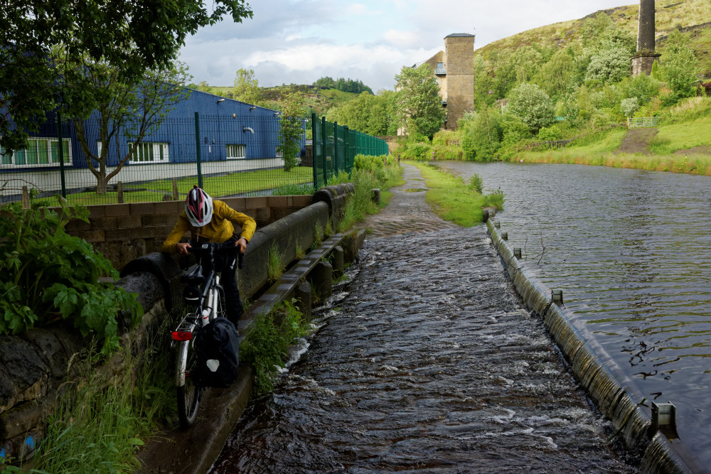
We made slow progress as the towpath rose up steeply on cobbles at each lock and we often had to dismount at bridges, with their cobbles, low headroom and sharp bends. At one point, a fallen tree blocked the towpath, forcing a detour. We enjoyed prolonged sunny spells but these were interrupted by frequent heavy downpours, deep puddles forming on the towpath. At a few places, the overflow drain had to be negotiated via a very narrow single plank bridge which was extremely tricky on laden bikes.
Hebden Bridge came into view at around 19:00 where we made our way to the airbnb property which we’d booked for two nights. Luckily our hosts had a hosepipe so we could wash our muddy bikes and bags before taking a shower ourselves. It was too late to shop and cook so we ate at the Old Gate pub, accompanied by a couple of pints of “Another day closer to the Grave” stout from Hopcraft Brewing, very welcome after a long day of travelling.