Spurn is a narrow sand tidal island located off the tip of the coast of the East Riding of Yorkshire, reaching into the North Sea and forming the north bank of the mouth of the Humber estuary. Prior to a severe storm in February 2017 which damaged part of the sandbank, Spurn was a spit with a permanent connection to the mainland. The island is over 3 miles (4.8 km) long and as little as 50 yards (46 m) wide in places. The southernmost tip is known as Spurn Head or Spurn Point and is the home to an RNLI lifeboat station and two disused lighthouses. It has been owned since 1960 by the Yorkshire Wildlife Trust and is a designated national nature reserve, heritage coast and is part of the Humber Flats, Marshes and Coast Special Protection Area. Because of the access difficulties, the lifeboat station will be relocated to the Lincolnshire side of the Humber near Grimsby.
Only the YWT’s all terrain vehicles are now allowed to drive to the end, these take weekend visitors on a tour which includes the lighthouse. As it was a Wednesday, the lighthouse was closed and access was only by foot or bike, though we had to push over the 300 metres or so of soft sand. The autumn bird migration season brings people in, but mid June sees little bird interest. I spotted a young roe deer which Christine scared off by screeching to a halt as I was about to photograph it.
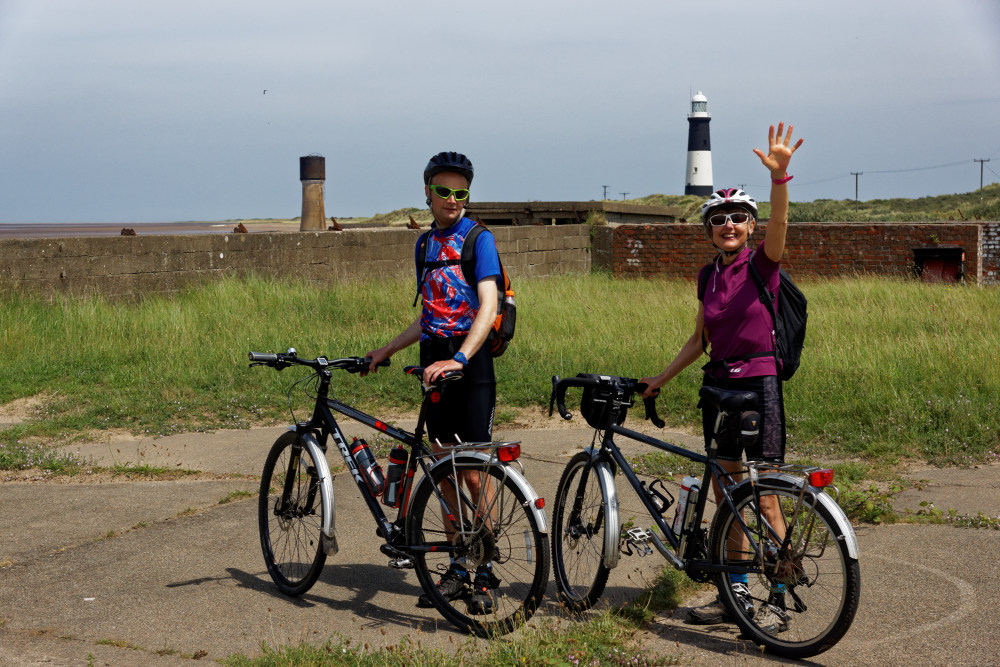
The earliest reference to a lighthouse on Spurn Point is 1427. From the 17th century there are records of a pair of lighthouses being maintained: a high light and a low light. In 1767, John Smeaton was commissioned to build a new pair of lighthouses. Smeaton’s high light, a 90 feet (27 m) tower, remained in use until 1895 but there were problems, as there had been in previous years, with maintaining the low light. Within a short time it had been washed away by the sea. A series of temporary replacements were used in the following years until a more solid lighthouse designed by James Walker was constructed in 1852. In 1895 both this low light and Smeaton’s high light were replaced by a single lighthouse, a round brick tower 128 feet (39 m) high, painted black and white. Its main light had a range of 17 nautical miles (20 miles, 31 km) and in addition there were separate sector lights, two of which marked particular shoals or sandbanks, while another indicated the main channel along the Humber. Due to improvements in navigation, the light was discontinued in 1985. The 1852 low light also still stands on the sandy shore of the island, though its lantern has been replaced by a large water tank.
There are also numerous wartime remains including rails from the military railway since Spurn was of strategic defensive importance. On our return we called in on the Blue Bell cafe for chocolate cake. It’s by the road to the original Kilnsea village which was long ago swallowed by the North Sea, this coastline being rapidly eroded.
We walked round the wetlands again and past the sound mirror, one of a number built on the northeast coast of England during the First World War. A forerunner of radar, they were intended to provide early warning of incoming enemy aeroplanes and airships and worked by focusing the noise of aircraft engines onto a microphone which amplified the sound. The microphone would have been fitted to a metal post in front of the mirror. An operator would use headphones to listen for an approaching enemy. These mirrors were only useful for detecting relatively slow aircraft, when speeds increased they gave insufficiently early warning and the invention of radar finally made them obsolete. Many were demolished but this rare survivor is now a national monument. We returned to the Crown and Anchor in the evening.