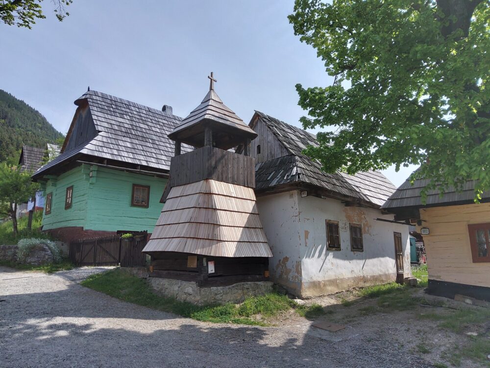
Vlkolínec
We were only 4 km from the UNESCO recognised wooden mediaeval village of Vlkolnic, though with a rise of 200 metres. Situated in the centre of Slovakia, it is a remarkably intact settlement with the traditional features of a central European village. It is the region’s most complete group of these kinds of traditional log houses, often found in mountainous areas. The village consists of more than 45 log houses, each consisting of two or three rooms. A wooden belfry from the 18th century as well as the baroque chapel have also been preserved. Houses No. 16 and 17 have been turned into a folk museum with all the instruments of daily life and work but were closed when we were there. A couple of cars passed us so we weren’t quite the first visitors of the day, more people arrived while we were surveying the scene. Twenty people still live there.
We rejoined the route, initially a path on the line of a narrow gauge railway closed in 1971. At Liptovska Osada the path met a road where fortuitously was a shop where we could buy lunch provisions and a bar. We sat out with a drink and enjoyed a chat with a young woman out for a ride with her family. She’d flown back from France where she works as a Erasmus coordinator. Freedom of Movement is such a wonderful concept, allowing a citizen of a country formerly under Russian control to work in another EU country and become fluent in French.
The main road was very busy with heavy vehicles and with regular roadworks. Our mapping software allows a choice of paved or any surface and today we chose “any” to avoid the road. Some of the old railway path was unpaved, sections being a dual line of single-track with grass in the middle.
We turned off the path at the end for a forest track which climbed up into the woods, at first with an acceptable surface but which became very rough and steep so we had to push our laden bikes. We kept thinking we’d soon reach the summit but it climbed relentlessly, taking us well above a thousand metres. Eventually it plateaued but we were dismayed to find it became a footpath and astonished to find a group of four people by a fire, the only ones we’d seen since leaving the railway path. They were engaged in the SNP trail, a 760 km hiking route which would take them 30 days.
They reassured us that the path eventually meets a track, as our mapping declared but first we had to get our bikes down. They also warned us that bears roamed these woods and to make a noise to keep them away. This was no joke, there are bears in Slovakia and we were in remote country. Cycling was out of the question, the route was so rough and in places boggy. We reached a sign indicating that the way ahead was closed, and an arrow pointing us down another path. We had no option but to follow it but while Christine was primarily worried about bears, I was more concerned about what we’d do if this track petered out, it was grassy and indistinct.
To our great relief it terminated at a road which was on the plotted route and we coasted downhill for miles. We stopped at a village railway station and found that a train to Banska Bystrica was due in a couple of minutes, which would regain some of the lost time, only a journey of about 20 minutes. Our tickets cost only 0.90 Euro each with the standard flat fare of 1.50 Euro per bike.
Our accommodation was a couple of miles south of the city and our mapping tool should have taken us straight there but was confused by the multitude of roads including a motorway and sent us off in the wrong direction. It’s rerouting capability usually works well but this time rerouted us as if it were trying to take us back to our starting point. We resorted to Google maps and frequent checking to reach the apartment, arriving two hours after reaching the city. We had our own kitchen so popped out to the nearby Tesco Extra, not sitting down to eat until 21:30.